Floods, Droughts, and Snow Melting: How Climate Change is Disrupting Livelihoods in Morocco
The upper Ounila catchment in Morocco has been losing yield, becoming more inhospitable due to climate change, and lacking agricultural benefits and knowledge to work with the land. The area’s harsh climate presents a difficult environment to achieve sustainable greening. With the changing climate, we can expect that land degradation, floods, and droughts in the catchment will continue to increase.
This year, AidEnvironment conducted research to provide insights into the current state of the catchment and identify the most pressing issues that need to be addressed to ensure sustainable water and land management practices. In this article, we will present our most important findings.
The upper Ounila catchment, which represents an area of 182 km2, is mainly drained by the Ounila river, which is an important source of agricultural water as most of the farms are situated along the water course. The climate of the catchment is characterized by hot temperatures and erratic and limited rainfall. Mean precipitation for the catchment is 646 mm/year while the average annual temperature is 160 Celsius. Despite the moderate precipitation, individual rain events can be intense. The hottest months are July and August while the coldest month is January. The very steep slopes have thick snow cover and rain during the winter period. Results show that the area under snow cover has decreased from 1985 to 2021. Also, there was a decreasing trend in rainfall indicated by a simple linear trendline which suggests declining rainfall in the Ounila catchment. Climate projections predict that Morocco will continue to face decrease in average precipitation, increase in temperatures, and increase in droughts and floods (World Bank Group (2021).
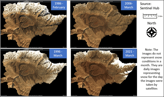
The white patches represent snow cover area on land surface (Source: Sentinel Hub, 2023)
Of particular interest to the study is understanding what caused the destructive flood of autumn 2014. Results show that the coinciding hot temperatures and high rainfall resulted in flash floods. Normally, high rainfall occurs during winter months where some of the precipitation is stored as snow. The snow usually acts as a buffer, preventing flooding. Shifting precipitation patterns are resulting in more rainfall that used to fall in winter months, to fall when it’s warmer which prevents formation of snow hence the rain becomes runoff. Due to climate change, more erratic rainfall and reduced snow cover are expected in the coming decades. These will probably result in more destructive flash floods unless water buffering interventions are implemented.
The study also identified other catchment issues as follows:
- High salinity of soils around salt licks, which renders the soil less suitable for agriculture and reforestation.
- The risk of seasonal water shortages especially during the dry seasons.
- Decreasing amounts of rainfall which is expected to lead to decreased groundwater recharge.
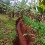
- Also, high rainfall intensity, unplanned clearing of natural vegetation, overgrazing and lack of landscape intervention projects results in more runoff and erosion.
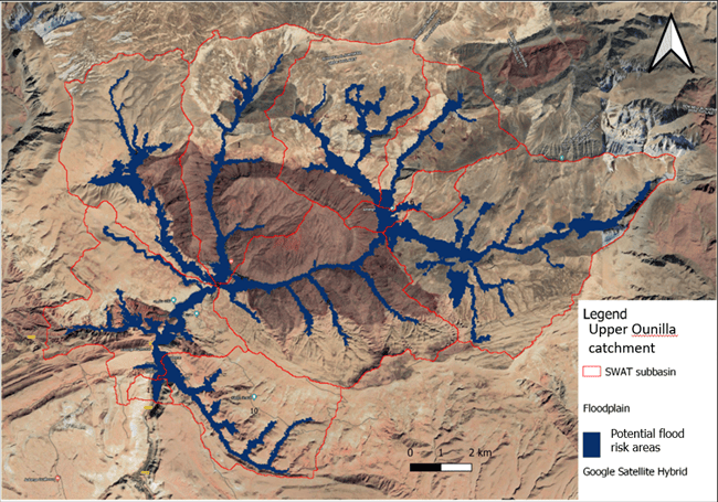
The figure shows upper Ounilla catchment. Areas in blue are potential flood risk areas in case of storm event.
A changing climate means that a larger share of rainfall will leave the upper Ounila catchment as fast runoff, instead of being released more slowly from the groundwater or melting snow. Combined with the changing land cover and declining rainfall, we can expect more floods and droughts.
Our landscape programming work considers existing challenges and future predictions to design sustainable solutions for restoration of ecosystems and improvement of livelihoods. We have designed solutions to restore the landscape areas under threat of flooding, protect lives and livelihoods and contribute to combating climate change.
This research was supported by Otter foundation and in collaboration with Perma atlas foundation.
Reference:
Climate Risk Profile: Morocco (2021): The World Bank Group https://climateknowledgeportal.worldbank.org/sites/default/files/2021-09/15725-WB_Morocco%20Country%20Profile-WEB.pdf (Accessed May 2023).
Modified Copernicus Sentinel data (2023)/ EO Browser, Sentinel Hub.